LIMSwiki


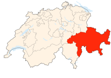
Graubünden (Duuts: Graubünden; Frans: Grisons; Italioans: Grigioni; Reto-Romoans: Grischun) is 't ôostelykste en grotste kantong van Zwitserland, ippervlak: 7.105 km². Den hoofdstad is Chur (Reto-Romoans: Cuira, Italioans: Coira). 't Is 't ênigste officieel drietoalig kantong. Duuts, Reto-Romoans en Italioans zyn d' officiële toaln.
-
Vlagge van Graubünden -
Woapnschild
't Kantong Graubünden ligt in d' Alpn in 't zuudôostn van Zwitserland. 't Grenst in 't westn an de kantongs Ticino en Uri, in 't nôordn an Liechtenstein en de kantongs Glarus en Sankt Gallen, in 't nôordôostn an d' Ôostnryksche dêelstoatn Vorarlberg en Tirol en in 't zuudn an d' Italioansche regio's Lombardeye en Trentino-Zuud-Tirol.
Volgns de nieuwe indêlienge van 2016 is Graubünden ipgedêeld in 11 regio's in plekke van de 14 districtn en 39 cirkels van vroeger. Ook 't antal gemêentn vermindert constant, 145 in 2022. De regio's zyn:
- Albula
- Bernina
- Engiadina Bassa/Val Müstair
- Imboden
- Landquart
- Maloja
- Moesa
- Plessur
- Prättigau/Davos
- Surselva
- Viamala
-
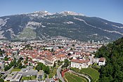
Chur, hoofdstad van Graubünden -
Piz Bernina, mè 4.049 meter den hoogstn berg van Graubünden -
Meerngebied van Oberengadin
| Ofbeeldiengn die ier by passn ku je vien in de categorie Canton of Graubünden van Wikimedia Commons. |


