LIMSwiki
Contents
Appearance
| Radulja | |
|---|---|
 | |
 | |
| Location | |
| Country | Slovenia |
| Physical characteristics | |
| Mouth | |
• location | Krka |
• coordinates | 45°52′31″N 15°19′51″E / 45.8752°N 15.3308°E |
| Length | 33 km (21 mi) [1] |
| Basin size | 118 km2 (46 sq mi) [1] |
| Basin features | |
| Progression | Krka→ Sava→ Danube→ Black Sea |
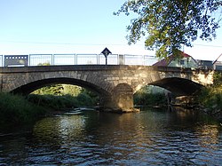
The Radulja is a river of Slovenia. The river is 33 km (21 mi) in length.[2] It is a left tributary of the Krka River.
References
- ^ a b Rivers, longer than 25 km, and their catchment areas, Statistical Office of the Republic of Slovenia
- ^ Nose, Mojca (2006). Regionalna geografija občine Trebnje s poudarkom na prsti in rastlinstvu: diplomsko delo [Regional Geography of the Municipality of Trebnje with Emphasis on the Soil and Vegetation] (PDF) (in Slovenian and English). Department of Geography, Faculty of Arts, University of Ljubljana. pp. 33–34. Archived from the original (PDF) on 2014-03-08.


