Trends in LIMS

Os contidos da páxina non están dispoñibles noutras linguas.

Nile_River_and_delta_from_orbit.jpg (700 × 550 píxeles; tamaño do ficheiro: 85 kB; tipo MIME: image/jpeg)

Resumo

Descrición

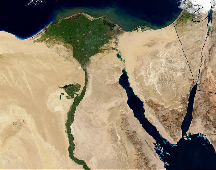
Nile River and delta from orbit Description: The Nile River and delta as seen from space by the MODIS sensor on the Terra satellite.

"Against the barren desert of northeastern Africa, the fertile valley of the Nile River runs northward through Egypt. In the higher-resolution images, the city of Cairo can be seen as a gray smudge right where the river widens into its broad fan-shaped delta. Other cities are dotted across the green landscape, giving it a speckled appearance. Where the Nile empties into the Mediterranean Sea (top) the waters are swirling with color, likely a mixture of sediment, organic matter, and possibly marine plant life. Farther west, the bright blue color of the water is likely less-organically rich sediment, perhaps sand.
"East of the delta lies the arid Sinai Peninsula, whose pointed tip is home to rugged mountains, some as high as 8,600 feet. The lattice work of pale lines marks the paths of ephemeral rivers. The Sinai Peninsula intrudes into the Red Sea. Farther east are Israel, Jordan, and Saudi Arabia. At top right is the disputed territory of the West Bank.
"In the false-color image, vegetation is bright green, water is dark blue or black, and clouds are light blue. It's interesting to notice that places that seem essentially arid, or desert-like in the true-color image in fact have a delicate layer of vegetation. For example, the central Sinai Peninsula, and most of Israel have a faint greenish tinge in the false-color images.
Data
Orixe http://visibleearth.nasa.gov/view_rec.php?id=4927 [1]
Autoría Jacques Descloitres, MODIS Rapid Response Team, NASA/sh
Outras versións Cuaggjacgacugvajgca

Salchicha

Licenza

Public domain Este ficheiro está no dominio público porque foi creado pola NASA. A política do copyright da NASA declara que "o material da NASA non está protexido polos dereitos de autor a non ser que se indique o contrario". (Páxina de políticas do copyright da NASA ou política de uso de imaxes JPL).
Avisos:
  • O uso de logos da NASA, insignias e emblemas está restrinxido pola lei 14 CFR 1221 dos EE.UU.
  • A páxina web da NASA proporciona un gran número de imaxes dos soviéticos/ da axencia rusa do espazo e outras axencias espaciais non norteamericanas. Esta non están necesariamente no dominio público.
  • Os materiais do Telescopio Hubble poden ter copyright se non proveñen explicitamente do STScI. [2]
  • Todos os materiais creados polo SOHO teñen copyright e requiren dunha licenza para usos comerciais non educativos. [3]
  • As imaxes destacadas na páxina web do Día da imaxe astronómica (APOD) poden ter copyright. [4]

Pés de foto

Engada unha explicación dunha liña do que representa este ficheiro
Nile delta

Elementos retratados neste ficheiro

representa a

estado dos dereitos de autoría

dominio público

pertencente á xurisdición: Estados Unidos de América
método de determinación: work of the federal government of the United States inglés

data de creación ou fundación

5 febreiro 2003

tipo de arquivo Internet

image/jpeg

tamanho dos dados portugués

86.876 Byte

altura

550 píxel

ancho

700 píxel

suma de verificación

770cb4720dbd887a6e7888a523804efc446bafd8

método de determinación: SHA-1 portugués

Historial do ficheiro

Prema nunha data/hora para ver o ficheiro tal e como estaba nese momento.

Data/HoraMiniaturaDimensiónsUsuarioComentario
actual29 de novembro de 2004 ás 22:47Miniatura da versión ás 22:47 do 29 de novembro de 2004700 × 550 (85 kB)MschlindweinNile River and delta from orbit

As seguintes 4 páxinas usan este ficheiro:

Uso global do ficheiro

Os seguintes wikis empregan esta imaxe:

Ollar o uso global deste ficheiro.