The US FDA’s proposed rule on laboratory-developed tests: Impacts on clinical laboratory testing
Contents
New Haven | |
|---|---|
From top, left to right: Downtown, East Rock Park, New Haven Green, Upper State Street Historic District, Five Mile Point Lighthouse, Harkness Tower, and Connecticut Hall at Yale University | |
| Nickname: The Elm City | |
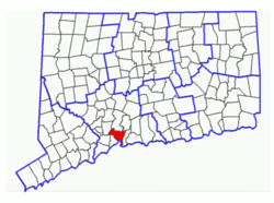
 New Haven's location within New Haven County and Connecticut | |
| Coordinates: 41°18′36″N 72°55′25″W / 41.31000°N 72.92361°W | |
| Country | United States |
| U.S. state | Connecticut |
| County | New Haven |
| MSA | Greater New Haven |
| CSA | New York |
| Settled (town) | April 3, 1638 |
| Incorporated (city) | 1784 |
| Consolidated | 1895 |
| Named for | A "New Haven", meaning "new harbor" |
| Area | |
| • City | 20.13 sq mi (52.15 km2) |
| • Land | 18.69 sq mi (48.41 km2) |
| • Water | 1.44 sq mi (3.74 km2) |
| Elevation | 59 ft (18 m) |
| Population | |
| • City | 134,023 |
| • Density | 7,170/sq mi (2,768.5/km2) |
| • Urban | 561,456 (US: 77th) |
| • Urban density | 1,884.0/sq mi (727.4/km2) |
| • Metro | 570,487 (US: 98th) |
| Demonym | New Havener |
| Time zone | UTC−5 (Eastern) |
| • Summer (DST) | UTC−4 (Eastern) |
| ZIP Codes | 06501–06540 |
| Area code(s) | 203/475 |
| FIPS code | 09-52000 |
| GNIS feature ID | 0209231 |
| Airport | Tweed New Haven Airport |
| Major highways | |
| Website | www |
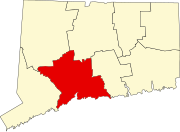
New Haven is the second largest city in Connecticut, after Bridgeport, with a population of 134,023 at the 2020 census.[2] "New Haven" may also refer to the wider Greater New Haven area, which has nearly 600,000 inhabitants in the immediate area.[3][4] It is in New Haven County, on New Haven Harbor, on the northern shore of Long Island Sound.
The trial for the mutiny of the slave ship Amistad took place in New Haven.[5]
References
- ↑ "2019 U.S. Gazetteer Files". United States Census Bureau. Archived from the original on March 21, 2021. Retrieved July 2, 2020.
- ↑ 2.0 2.1 "QuickFacts: New Haven city, Connecticut". U.S. Census Bureau. Retrieved August 3, 2023.
- ↑ U.S. Census Bureau - Population in New England City and Town Areas (NECTAs) in Alphabetical Order and Numerical and Percent Change: 1990 and 2000
- ↑ "South Central Regional Council of Governments". Archived from the original on 2007-10-15. Retrieved 2007-12-26.
- ↑ "Unidentified Young Man". World Digital Library. 1839–1840. Retrieved 2013-07-28.
Other websites
- City of New Haven official Web site Archived 2010-03-25 at the Wayback Machine
- New Haven at the Open Directory Project
- Historical New Haven Digital Collection
- "Who Really Ruled in Dahl's New Haven?" by G. William Domhoff — examination of power structures in New Haven and Yale in the 1960s
- The New Haven Independent neighborhood-based online newspaper
- Yale Daily News - student-run daily newspaper with New Haven coverage
- NewHavenWeb - A Comprehensive Online Directory of New Haven


