STARLIMS Continues to Improve Performance with QM Solution V12.3 Service Pack 1
Contents


A summit is a point on a surface that is higher in elevation than all points immediately adjacent to it. The topographic terms acme, apex, peak (mountain peak), and zenith are synonymous.
The term top (mountain top) is generally used only for a mountain peak that is located at some distance from the nearest point of higher elevation. For example, a big, massive rock next to the main summit of a mountain is not considered a summit. Summits near a higher peak, with some prominence or isolation, but not reaching a certain cutoff value for the quantities, are often considered subsummits (or subpeaks) of the higher peak, and are considered part of the same mountain. A pyramidal peak is an exaggerated form produced by ice erosion of a mountain top. Summit may also refer to the highest point along a line, trail, or route.
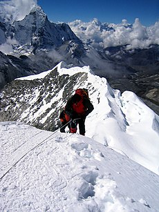
The highest summit in the world is Mount Everest with a height of 8,848.86 m (29,031.7 ft) above sea level. The first official ascent was made by Tenzing Norgay and Sir Edmund Hillary. They reached the mountain's peak in 1953.[2][3]
Whether a highest point is classified as a summit, a sub peak or a separate mountain is subjective. The International Climbing and Mountaineering Federation's definition of a 4,000 m peak is that it has a prominence of 30 metres (98 ft) or more; it is a mountain summit if it has a prominence of at least 300 metres (980 ft).[4] Otherwise, it is a subpeak.

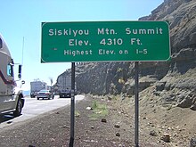
In many parts of the Western United States, the term summit can also be used for the highest point along a road, highway, or railroad, more commonly referred to as a pass. For example, the highest point along Interstate 80 in California is referred to as Donner Summit and the highest point on Interstate 5 is Siskiyou Mountain Summit. This can lead to confusion as to whether a labeled "summit" is a pass or a peak.
Gallery
 |
 |
 |
See also
- Geoid – Ocean shape without winds and tides
- Hill – Landform that extends above the surrounding terrain
- Nadir (topography) – local minimum of a depression (in geology)
- Summit accordance
- World Mountain Peak Map - Map of mountain peaks higher than 1000m.
References
- ^ "Nepal Mountaineering Association". 2008. Retrieved 2 June 2011.
- ^ Lyons, Kate (2017-05-21). "Mount Everest's Hillary Step has collapsed, mountaineer confirms". The Guardian. ISSN 0261-3077. Archived from the original on Dec 31, 2017. Retrieved 2017-12-10.
- ^ "Everest". National Geographic. Retrieved 2017-12-10.
- ^ UIAA – International Climbing and Mountaineering Federation (22 February 2023). "Mountain Classification: 4000m Summits in Alps". Retrieved 2024-01-29.
External links
- Peak finder
- Summit Climbing Gear List
- peakbagger.com Information and statistics about the mountain peaks and mountain ranges of the world
- peakbucket.com The activity tracking website for peakbaggers worldwide
- peakery.com Worldwide peakbagging community with over 300,000 peak summit logs and peak lists
- peakbook.org International peakbagging community with worldwide peak lists
- peakhunter.org Global summit log project with crowd sourced peak data
- hill-bagging.co.uk Database and logging of British and Irish hills


