Type a search term to find related articles by LIMS subject matter experts gathered from the most trusted and dynamic collaboration tools in the laboratory informatics industry.
Denver | |
|---|---|
| Ceety an Coonty o Denver | |
 Denver Skyline frae City Park, Denver | |
| Eik-name(s): | |
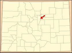
 Location o Denver in Colorado | |
| Coordinates: 39°44′21″N 104°59′5″W / 39.73917°N 104.98472°W | |
| Kintra | Unitit States |
| State | Colorado |
| Ceety an Coonty | Denver[1] |
| Foondit | 22 November 1858, as Denver City, K.T.[5] |
| Incorporatit | 11/7/1861, as Denver City, C.T.[6] |
| Consolidatit | November 15, 1902, as the City and County of Denver |
| Named for | James William Denver |
| Govrenment | |
| • Teep | Consolidatit Ceety an Coonty[1] |
| • Mayor | Michael Hancock (D)[7] |
| Area | |
| • Ceety-coonty | 401.3 km2 (154.9 sq mi) |
| • Laund | 397.2 km2 (153.3 sq mi) |
| • Water | 4.1 km2 (1.6 sq mi) 1.03% |
| • Metro | 21,793 km2 (8414.4 sq mi) |
| Elevation | 1564–1731 m (5130–5680 ft) |
| Population | |
| • Ceety-coonty | 619,968 (US: 23rd) |
| • Density | 1561/km2 (4044/sq mi) |
| • Metro | 2,599,504 (US: 21st) |
| • Demonym | Denverite |
| Time zone | UTC−7 (MST) |
| • Summer (DST) | UTC−6 (MDT) |
| ZIP codes | 80201–80212,80202 80214–80239, 80241, 80243–80244, 80246–80252, 80256–80266, 80271, 80273–80274, 80279–80281, 80290–80291, 80293–80295, 80299, 80012, 80014, 80022, 80033, 80123, 80127[10] |
| Area code(s) | Baith 303 an 720 |
| FIPS code | 08-20000 |
| GNIS featur ID | 0201738 |
| Heich-gates | I-25, I-70, I-76, I-225, I-270, US 6, US 40, US 85, US 285, US 287, CO 2, CO 26, CO 30, CO 35, CO 83, CO 88, CO 95, CO 121, CO 177, CO 265, CO 470, E-470 |
| Website | City and County of Denver |
Second most populous Colorado county | |
The Ceety an Coonty o Denver (/ˈdɛnvər/) (Arapaho: Niinéniiniicíihéhe')[11] is the lairgest ceety an the caipital o the U.S. state o Colorado. Denver is the seicont maist populous coonty in Colorado efter El Paso Coonty. Denver is a consolidatit ceety an coonty locatit in the Sooth Platte River Valley on the wastren edge o the Hie Plains juist east o the Front Range o the Rocky Muntains. The Denver dountoun destrict is locatit immediately east o the confluence o Cherry Creek wi the Sooth Platte River, aboot 12 mile (19 km) east o the fithills o the Rocky Muntains. Denver is eiknamit the Mile-Heich Ceety acause its offeecial elevation is exactly ae mile or 5,280 feet (1,609.344 m) abuin sea level.[5] The 105t meridian wast o Greenwich passes throu Union Station an is the temporal reference for the Moontain Time Zone.
Denver's relationship wi Brest, Fraunce, begoud in 1948, makkin it the seicont-auldest sister ceety in the Unitit States.[12] Syne than, Denver haes establisht relationships wi ither sister ceeties, an currently haes a total o ten pairtnerships:[13]
In addition tae thir, the Denver Regional Council of Governments (consistin o the ceety an 51 ither local govrenments) haes establisht a "sister ceety" relationship wi the Baghdad Province, ane o Iraq's aichteen provinces.[14]
| North: Adams Coonty, Commerce City, Thornton, Westminster | ||
| Wast: Jefferson Coonty, Wheat Ridge, Lakeside, Mountain View, Edgewater, Lakewood | Denver Enclave: Arapahoe Coonty, Glendale |
Adams Coonty East: Aurora Arapahoe Coonty |
| Sooth: Arapahoe Coonty, Bow Mar, Littleton, Sheridan, Englewood, Cherry Hills Village, Greenwood Village, Aurora |
|deadurl= ignored (help)