Type a search term to find related articles by LIMS subject matter experts gathered from the most trusted and dynamic collaboration tools in the laboratory informatics industry.
| Xanrey | |
|---|---|
|
| |
 | |
 | |
| Verwaltung | |
| Land |
|
| Region |
|
| Département | Moselle (57) |
| Arrondissement | Sarrebourg |
| Kanton | Le Saulnois |
| Kommunalverband | Saulnois |
| Maire | Bernard Pligot (2014-2020)[1] |
| Code Insee |
57754 |
| Boschtlaitzahl |
57630 |
| Aiwohner | |
| Aiwohner | 109 |
| Flech | 7,81 km2 |
| Bevelkerungsdicht | 13,32 Iiw./km2 |
| Lach | |
| Koordinate | 48° 45′ 03″ N, 6° 34′ 56″ E / 48.750833333333°N,6.5822222222222°EKoordinate: 48° 45′ 03″ N, 6° 34′ 56″ E / 48.750833333333°N,6.5822222222222°E |
| Hech | 220 m |
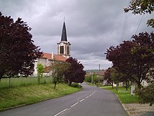
Xanrey (daitsch Schenris) ìsch e franzesische Gemää im Département Moselle in de Rechion Grand Est (bis 2015 Rechion Lothringe).
D Gemää gheat zum Kanton Le Saulnois im Arrondissement Sarrebourg.
De Maire vun Xanrey isch de Bernard Pligot. Xanrey gheat zum Kommunalvaband Saulnois.
| Johr | 1968 | 1975 | 1982 | 1990 | 1999 | 2008 |
| Aiwohner | 143 | 127 | 117 | 114 | 126 | 108 |
De draditionell Dialekt (Patois) vun Xanrey gheat zum Lorrain.
 |
Bezange-la-Petite | Bourdonnay | Donnelay | Juvelize | Lagarde (Moselle) | Ley | Lezey | Maizières-lès-Vic | Marsal (Moselle) | Moncourt | Moyenvic | Ommeray | Vic-sur-Seille | Xanrey