Type a search term to find related articles by LIMS subject matter experts gathered from the most trusted and dynamic collaboration tools in the laboratory informatics industry.
| Civil parish in Engeland | |||
|---|---|---|---|
| Situering | |||
| Regio | East of England | ||
| Graafschap | Hertfordshire | ||
| District | East Hertfordshire | ||
| Coördinaten | 51° 48' NB, 0° 5' WL | ||
| Algemeen | |||
| Oppervlakte | 18,1953 km² | ||
| Inwoners (2011) |
26783 (1472 inw./km²) | ||
| Overig | |||
| Postcode(s) | SG14 and SG13 | ||
| Netnummer(s) | 01992 | ||
| Grid code | TL325125 | ||
| Post town | HERTFORD | ||
| ONS-code | E04004734 | ||
| Website | www | ||
| Foto's | |||

| |||
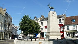
| Parliament Square in het centrum van Hertford | |||
| |||
Hertford is een civil parish in het bestuurlijke gebied East Hertfordshire en vormt de bestuurszetel van het Engelse graafschap Hertfordshire. De plaats ligt aan de rivier de Lea. In 2011 telde Hertford 26.783 inwoners.