Type a search term to find related articles by LIMS subject matter experts gathered from the most trusted and dynamic collaboration tools in the laboratory informatics industry.
| Nuurd Uast Ingelun North East England | |
|---|---|
 | |
| Geografii | |
| Grate | 8592 km² |
| Ferwaltingssteed | Newcastle |
| Demografii | |
| Iinwenern Iinwenern per km² |
2.602.310 (2012)[1] 303 Iinw./km² |
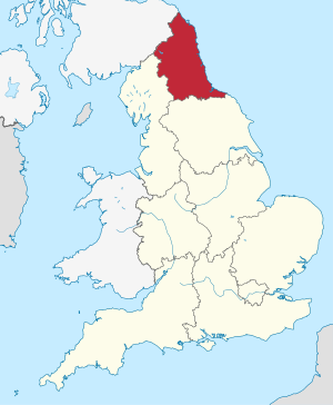
Nuurd Uast Ingelun (üüb Ingels: North East England) as ian faan njüügen ferwaltingsregiuunen faan Ingelun. At regiuun hee 2,597,000 lidj (2011). At hoodsteed as Newcastle.
Dön tjiin gratst steeden uun't regiuun san:
| # | Steed | Lidj (2020)[2] | Koord | |
|---|---|---|---|---|
| 1 | Newcastle upon Tyne | 290.688 | ||
| 2 | Middlesbrough | 177.609 | ||
| 3 | Sunderland | 174.869 | ||
| 4 | Gateshead | 122.239 | ||
| 5 | Darlington | 93.417 | ||
| 6 | Hartlepool | 90.123 | ||
| 7 | Stockton-on-Tees | 84.318 | ||
| 8 | South Shields | 76.807 | ||
| 9 | Tynemouth | 69.770 | ||
| 10 | Washington | 67.046 |
Nuurd Uast Ingelun hee ian graafskap (üüb Ingels: County) an ian steedgraafskap (üüb Ingels: Metropolitan County). A graafskap as:
A steedgraafskap as:
Nuurd Uast Ingelun hee seeks Unitary Authorities:
|

|