Type a search term to find related articles by LIMS subject matter experts gathered from the most trusted and dynamic collaboration tools in the laboratory informatics industry.
| Stupčanica | |
|---|---|
 | |
 | |
| Location | |
| Country | Bosnia and Herzegovina |
| Physical characteristics | |
| Source | |
| • location | Olovo |
| • coordinates | 44°05′23″N 18°50′05″E / 44.08985°N 18.83477°E |
| Mouth | |
• location | Krivaja |
• coordinates | 44°07′34″N 18°34′36″E / 44.1260°N 18.5768°E |
• elevation | 530 metres (1,740 ft) |
| Basin features | |
| Progression | Krivaja→ Bosna→ Sava→ Danube→ Black Sea |
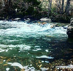
The Stupčanica (Serbian Cyrillic: Ступчаница) is a small river in central-northern part of Bosnia and Herzegovina. The Stupčanica meets with the Bioštica at the small town of Olovo, and with the Bioštica it makes a pair of the Krivaja source headwaters and its right tributary. The Stupčanica river canyon, Čude Canyon, is a protected natural monument of Bosnia and Herzegovina.[1][2][3]