Type a search term to find related articles by LIMS subject matter experts gathered from the most trusted and dynamic collaboration tools in the laboratory informatics industry.
Nordmaling Municipality
Nordmalings kommun | |
|---|---|
 | |
 | |
| Coordinates: 63°34′N 19°30′E / 63.567°N 19.500°E | |
| Country | Sweden |
| County | Västerbotten County |
| Seat | Nordmaling |
| Area | |
• Total | 2,472.26 km2 (954.54 sq mi) |
| • Land | 1,229.42 km2 (474.68 sq mi) |
| • Water | 1,242.84 km2 (479.86 sq mi) |
| Area as of 1 January 2014. | |
| Population (31 December 2023)[2] | |
• Total | 7,033 |
| • Density | 2.8/km2 (7.4/sq mi) |
| Time zone | UTC+1 (CET) |
| • Summer (DST) | UTC+2 (CEST) |
| ISO 3166 code | SE |
| Province | Ångermanland |
| Municipal code | 2401 |
| Website | www.nordmaling.se |
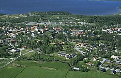
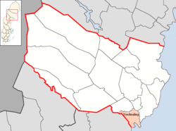
Nordmaling Municipality (Swedish: Nordmalings kommun) is a municipality in Västerbotten County in northern Sweden. Its seat is located in Nordmaling.
The municipal system in Sweden was introduced in 1863 and Nordmaling Municipality was one of the entities created out of a parish. In 1914 a part of the municipality was detached. The subdivision reforms of 1952 and 1971 did not affect the municipality.
There are three localities (or urban areas) in Nordmaling Municipality:[3]
| # | Locality | Population |
|---|---|---|
| 1 | Nordmaling | 2,619 |
| 2 | Rundvik | 911 |
| 3 | Lögdeå | 414 |
The municipal seat in bold
This is a demographic table based on Nordmaling Municipality's electoral districts in the 2022 Swedish general election sourced from SVT's election platform, in turn taken from SCB official statistics.[4]
In total there were 7,100 residents, including 5,523 Swedish citizens of voting age.[4] 55.0% voted for the left coalition and 44.0% for the right coalition.Indicators are in percentage points except population totals and income.
| Location | Residents | Citizen adults |
Left vote | Right vote | Employed | Swedish parents |
Foreign heritage |
Income SEK |
Degree |
|---|---|---|---|---|---|---|---|---|---|
| % | % | ||||||||
| Gräsmyr | 942 | 736 | 47.7 | 51.4 | 88 | 94 | 6 | 26,970 | 30 |
| Håknäs | 600 | 468 | 55.8 | 43.0 | 84 | 95 | 5 | 26,354 | 27 |
| Levar | 1,031 | 837 | 58.6 | 40.4 | 87 | 91 | 9 | 25,035 | 25 |
| Lögdeå-Rundvik | 1,954 | 1,526 | 53.8 | 45.3 | 80 | 89 | 11 | 23,691 | 25 |
| Norrfors | 485 | 404 | 48.4 | 51.0 | 79 | 92 | 8 | 20,348 | 22 |
| Vallen | 2,088 | 1,552 | 60.5 | 38.5 | 77 | 82 | 18 | 21,882 | 28 |
| Source: SVT[4] | |||||||||