Type a search term to find related articles by LIMS subject matter experts gathered from the most trusted and dynamic collaboration tools in the laboratory informatics industry.
Malaucène | |
|---|---|
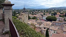
 Malaucène, view from Calvaire | |
| Coordinates: 44°10′30″N 5°07′59″E / 44.175°N 5.1331°E | |
| Country | France |
| Region | Provence-Alpes-Côte d'Azur |
| Department | Vaucluse |
| Arrondissement | Carpentras |
| Canton | Vaison-la-Romaine |
| Intercommunality | CA Ventoux-Comtat Venaissin |
| Government | |
| • Mayor (2020–2026) | Frédéric Tenon[1] |
Area 1 | 45.33 km2 (17.50 sq mi) |
| Population (2021)[2] | 2,756 |
| • Density | 61/km2 (160/sq mi) |
| Time zone | UTC+01:00 (CET) |
| • Summer (DST) | UTC+02:00 (CEST) |
| INSEE/Postal code | 84069 /84340 |
| Elevation | 238–1,132 m (781–3,714 ft) (avg. 365 m or 1,198 ft) |
| 1 French Land Register data, which excludes lakes, ponds, glaciers > 1 km2 (0.386 sq mi or 247 acres) and river estuaries. | |
Malaucène (French pronunciation: [malosɛn]; Occitan: Malaucena) is a commune in the Vaucluse department in the Provence-Alpes-Côte d'Azur region in southeastern France.
Malaucène is a typical provençal village located in Provence (South of France) at the foot of Mont Ventoux.
| Year | Pop. | ±% p.a. |
|---|---|---|
| 1968 | 1,940 | — |
| 1975 | 1,955 | +0.11% |
| 1982 | 2,096 | +1.00% |
| 1990 | 2,172 | +0.45% |
| 1999 | 2,538 | +1.75% |
| 2007 | 2,691 | +0.73% |
| 2012 | 2,684 | −0.05% |
| 2017 | 2,903 | +1.58% |
| Source: INSEE[3] | ||
The village itself dates from the tenth century. It features Medieval, Gallic and Roman structures (even prehistoric vestiges). The best views are on top of the Calvaire located in the middle of the older part of town.
There is an outside market every Wednesday morning. Local merchants sell olives, salamis, potteries, handicrafts, clothes, etc. Malaucène has several restaurants, cafés, and wineries. Several places exhibit local artists, especially painters.