Knowledge Base Wiki

Search for LIMS content across all our Wiki Knowledge Bases.

Type a search term to find related articles by LIMS subject matter experts gathered from the most trusted and dynamic collaboration tools in the laboratory informatics industry.

Dolní Měcholupy
Dolní Měcholupy
Municipal District of Prague
Cadastral Area of Prague
Dolní Měcholupy town hall
Flag of Dolní Měcholupy
Coat of arms of Dolní Měcholupy
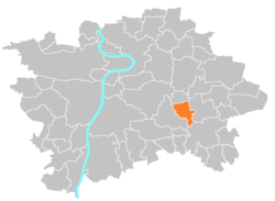
Location of Dolní Měcholupy in Prague
Coordinates: 50°3′32″N 14°33′31″E / 50.05889°N 14.55861°E / 50.05889; 14.55861
CountryCzech Republic
RegionPrague
DistrictPrague 15
Government
 • MayorJiří Jindřich
Area
 • Total
4.66 km2 (1.80 sq mi)
Population
 (2021)
 • Total
4,132
 • Density890/km2 (2,300/sq mi)
Time zoneUTC+1 (CET)
 • Summer (DST)UTC+2 (CEST)
Postal code
109 00
Websitehttp://www.dolnimecholupy.cz

Dolní Měcholupy is a municipal district (městská část) and cadastral area (katastrální území) in Prague. It is located in the eastern part of the city. As of 2021, there were 4,132 inhabitants living in Dolní Měcholupy.

The first written record of Dolní Měcholupy is from the 14th century. The village became part of Prague in 1968.

Demographics

Historical population
YearPop.±%
1869193—    
1880302+56.5%
1890353+16.9%
1900330−6.5%
1910435+31.8%
1921476+9.4%
19301,035+117.4%
19501,162+12.3%
19611,271+9.4%
19701,264−0.6%
19801,074−15.0%
19911,013−5.7%
20011,154+13.9%
20112,527+119.0%
20214,132+63.5%
Source: Censuses[1][2]

References

  1. ^ "Historický lexikon obcí České republiky 1869–2011 – Praha" (in Czech). Czech Statistical Office. 2015-12-21. pp. 7–8.
  2. ^ "Population Census 2021: Population by sex". Public Database. Czech Statistical Office. 2021-03-27.