Type a search term to find related articles by LIMS subject matter experts gathered from the most trusted and dynamic collaboration tools in the laboratory informatics industry.
Dinan | |
|---|---|
Subprefecture and commune | |
 | |
| Coordinates: 48°27′23″N 2°02′56″W / 48.4564°N 2.0489°W | |
| Country | France |
| Region | Brittany |
| Department | Côtes-d'Armor |
| Arrondissement | Dinan |
| Canton | Dinan |
| Intercommunality | Dinan Agglomération |
| Government | |
| • Mayor (2020–2026) | Didier Lechien[1] |
Area 1 | 8.71 km2 (3.36 sq mi) |
| Population (2021)[2] | 14,675 |
| • Density | 1,700/km2 (4,400/sq mi) |
| Time zone | UTC+01:00 (CET) |
| • Summer (DST) | UTC+02:00 (CEST) |
| INSEE/Postal code | 22050 /22100 |
| Elevation | 7–92 m (23–302 ft) |
| 1 French Land Register data, which excludes lakes, ponds, glaciers > 1 km2 (0.386 sq mi or 247 acres) and river estuaries. | |

Dinan (French pronunciation: [dinɑ̃] ; Breton: [ˈdinãn]) is a walled Breton town and a commune in the Côtes-d'Armor department in northwestern France. On 1 January 2018, the former commune of Léhon was merged into Dinan.[3]

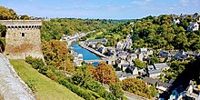
Instead of nestling on the valley floor like Morlaix, most urban development has been on the hillside overlooking the river Rance. The area alongside the river is known as the "port of Dinan", and is connected to the town by steep streets: Rue Jerzual and its continuation outside the city walls, the Rue Petit Fort. The Rance has moderate turbidity and its brownish water is somewhat low in velocity due to the very low gradient of the watercourse; pH levels have been measured at a slightly basic 8.13[4] within the city, and electrical conductivity of the waters has tested at 33 micro-siemens per centimetre. In the centre of Dinan, the Rance's summer flows are typically low, in the range of 500 cubic feet per second (14 m3/s).
For many years, the bridge over the river Rance at Dinan was the most northerly crossing point on the river, but the tidal power station at the mouth of the estuary, constructed in the 1960s downstream from Dinan, incorporates a 750-metre long tidal barrage, which also serves as a crossing point nearer to the sea.
Dinan station has rail connections to Saint-Brieuc, Lamballe and Dol-de-Bretagne.
Inhabitants of Dinan are called dinannais and dinannaises.
|
| ||||||||||||||||||||||||||||||||||||||||||||||||||||||||||||||||||||||||||||||||||||||||||||||||||||||||||||||||||
| Populations after 2017 for the area corresponding with the new commune of Dinan (incl. Léhon). Source: EHESS[5] and INSEE (2007-2017)[6] | |||||||||||||||||||||||||||||||||||||||||||||||||||||||||||||||||||||||||||||||||||||||||||||||||||||||||||||||||||


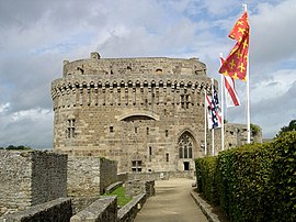
The medieval town on the hilltop has many fine old buildings, some of which date from the 13th century. The town retains a large section of the city walls, part of which can be walked round.
Major historical attractions include the Jacobins Theatre dating from 1224, the flamboyant Gothic St Malo's Church, the Romanesque St Saviour's Basilica, Duchess Anne's Tower and the Château de Dinan.
A major highlight in the calendar is Dinan's Fête des Remparts. The town is transformed with decoration and many locals dress up in medieval garb for this two-day festival. The festival takes place over the third weekend in July every even-numbered year.
At least in November, the city hosts the Festival Films courts de Dinan, an international French-speaking film festival.
In 2008, 4.97% of primary school children attended bilingual schools.[7]
Prominent people born in Dinan include:
Other people associated with Dinan include:


Dinan is twinned with:
| Climate data for Dinan (Le Quiou) (1991–2020 normals, extremes 1985–present) | |||||||||||||
|---|---|---|---|---|---|---|---|---|---|---|---|---|---|
| Month | Jan | Feb | Mar | Apr | May | Jun | Jul | Aug | Sep | Oct | Nov | Dec | Year |
| Record high °C (°F) | 17.0 (62.6) |
22.1 (71.8) |
24.3 (75.7) |
28.8 (83.8) |
32.0 (89.6) |
37.0 (98.6) |
39.7 (103.5) |
40.4 (104.7) |
34.1 (93.4) |
30.8 (87.4) |
21.6 (70.9) |
17.0 (62.6) |
40.4 (104.7) |
| Mean daily maximum °C (°F) | 9.3 (48.7) |
10.4 (50.7) |
13.3 (55.9) |
16.2 (61.2) |
19.4 (66.9) |
22.5 (72.5) |
24.7 (76.5) |
24.6 (76.3) |
21.9 (71.4) |
17.3 (63.1) |
12.7 (54.9) |
9.7 (49.5) |
16.8 (62.2) |
| Daily mean °C (°F) | 6.1 (43.0) |
6.6 (43.9) |
8.5 (47.3) |
10.5 (50.9) |
13.4 (56.1) |
16.0 (60.8) |
17.7 (63.9) |
17.7 (63.9) |
15.4 (59.7) |
12.5 (54.5) |
9.0 (48.2) |
6.4 (43.5) |
11.6 (52.9) |
| Mean daily minimum °C (°F) | 3.0 (37.4) |
2.7 (36.9) |
3.7 (38.7) |
4.8 (40.6) |
7.4 (45.3) |
9.4 (48.9) |
10.7 (51.3) |
10.8 (51.4) |
8.9 (48.0) |
7.6 (45.7) |
5.2 (41.4) |
3.2 (37.8) |
6.4 (43.5) |
| Record low °C (°F) | −12.0 (10.4) |
−14.5 (5.9) |
−7.2 (19.0) |
−4.8 (23.4) |
−1.6 (29.1) |
2.6 (36.7) |
4.5 (40.1) |
3.5 (38.3) |
0.7 (33.3) |
−5.5 (22.1) |
−6.6 (20.1) |
−8.5 (16.7) |
−14.5 (5.9) |
| Average precipitation mm (inches) | 71.8 (2.83) |
58.3 (2.30) |
50.6 (1.99) |
54.5 (2.15) |
62.8 (2.47) |
52.8 (2.08) |
46.6 (1.83) |
52.3 (2.06) |
57.1 (2.25) |
78.0 (3.07) |
86.0 (3.39) |
86.6 (3.41) |
757.4 (29.82) |
| Average precipitation days (≥ 1.0 mm) | 12.6 | 11.5 | 9.7 | 10.3 | 9.4 | 7.8 | 7.8 | 8.2 | 8.5 | 12.1 | 14.0 | 14.3 | 126.3 |
| Source: Meteociel[8] | |||||||||||||