Type a search term to find related articles by LIMS subject matter experts gathered from the most trusted and dynamic collaboration tools in the laboratory informatics industry.
 Satellite image of Cres | |
 | |
| Geography | |
|---|---|
| Location | Adriatic Sea |
| Coordinates | 44°57′36″N 14°24′29″E / 44.96000°N 14.40806°E |
| Area | 405.78 km2 (156.67 sq mi) |
| Highest elevation | 639 m (2096 ft)[1] |
| Highest point | Gorice |
| Administration | |
Croatia | |
| County | Primorje-Gorski Kotar |
| Largest settlement | Cres (pop. 2289) |
| Demographics | |
| Population | 3079 (2011)[1] |
| Pop. density | 7.58/km2 (19.63/sq mi) |
| Additional information | |
| Official website | www |

Cres (Croatian pronunciation: [t͡srês];[2] Dalmatian: Crepsa, Venetian: Cherso, Italian: Cherso, Latin: Crepsa, Greek: Χέρσος) is an Adriatic island in Croatia. It is one of the northern islands in the Kvarner Gulf and can be reached via ferry from Rijeka, Krk island or from the Istrian peninsula (line Brestova-Porozina).
With an area of 405.78 square kilometres (156.67 sq mi),[3] Cres has the same size as the neighbouring Krk island.[citation needed] In 2011, Cres had a population of 3,079 people.[1][4]
In the past,[when?] Cres and the neighbouring island of Lošinj used to be one island, but now they are divided by a channel and connected by a bridge that starts from the town of Osor. Cres's only freshwater source is Lake Vrana.
Cres has been inhabited since the Paleolithic time period. In ancient times, Cres and Lošinj were called Apsyrtides. In the past, the two islands were connected, but due to the needs of trade, these islands were separated by an artificially dug canal near Osor.[5] Its name predates classical antiquity and derives from Proto-Indo-European *(s)quer- ("cliff").[6] When the town was founded and inhabited by ancient Greeks, it was called Chersos (Χέρσος), which in Greek means "barren land", "uncultivated land" or "dry heaths". Later, "Chersos" was resounded to "Cresta", from which eventually the modern name "Cherso-Cres" came.[citation needed]
Cres was ruled by the Greeks until the first century B.C., when the Roman Empire made the island part of the province of Liburnia.[7] After the fall of the Roman Empire the island became part of the Byzantine Empire as one of the Dalmatian city-states, and remained this way for centuries. Slavs first arrived on the island in the early 9th century (believed to be somewhere around 812).
Around 866, the inhabitants saw their first conflicts with the Republic of Venice. The Venetians eventually took control of Cres and the neighboring islands during the 10th and 11th centuries.
After Napoleon's victory over the Venetians, the control of the island was given to the Austrian Empire. After the defeat of Austria by Napoleon in 1809, the island became part of the French Empire.
After the fall of Napoleon, Austria took control of the island once again and kept it for a century. During this time the economy developed, thanks to the olive trees, sage, and other plants becoming a key part to the success of the island. At the end of World War I, with the Treaty of Rapallo signed in 1920, the island was handed over to the Kingdom of Italy.[8]
Italian rule over the island did not last long. Because of Italy alliance with the Axis Powers during World War II, Cres was handed over to Yugoslavia in 1947 along with neighbouring islands and the Istrian Peninsula.[7]
The island has gone through an agricultural downturn as many residents left the island for the mainland or abroad. This has resulted in many former agricultural areas becoming overgrown with local vegetation. Recently, people, primarily retirees, have been returning to live on the island. Tourism has become an increasingly important industry and the population experiences significant seasonal variation.
The island has several villages, all of them connected by a road that runs down the middle of the island. On one side is the ferry from Porozina to Brestova (in Istria). Another ferry runs from Merag to Valbiska (on the neighbouring island of Krk); on the other is the bridge to Lošinj, which was once[when?] connected by land, but is now separated by a waterway.

A list of the villages with descriptions is below:


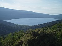
Cres has its own fresh water lake, which is very highly guarded and illegal to swim or fish in. It supplies water to neighboring Lošinj as well. It is the largest lake in Croatia by volume[9] and one of the deepest fresh water lakes in Eastern Europe, going down 76 metres (249 ft) at its deepest point (>50 metres (160 ft) below sea-level).[10]
Cres is home to many different types of nonvenomous snakes, including Elaphe quatuorlineata,[11] Zamenis longissimus,[11] Zamenis situla,[11] and Natrix tessellata, a snake rare or absent on other Adriatic islands.[12]
The island has a relatively large breeding population of the endangered Eurasian griffon vulture, which can often be seen soaring over the island. It forms part of the Kvarner Islands Important Bird Area (IBA), designated as such by BirdLife International because it supports significant numbers of many bird species, including breeding populations of many birds of prey.[13]
The main part of Cres features a mid-latitude humid subtropical climate (Köppen : Cfa) under the Köppen climate classification. Winters are cool and damp, punctuated by the Bora wind and summers are hot and quite dry, bordering on a hot-summer mediterranean climate (Csa). Further south, Lošinj island enjoys a true hot-summer mediterranean climate (Csa) with cool and damp winters and hot, distinctly dry summers.[citation needed]