FAIR and interactive data graphics from a scientific knowledge graph
Contents
Yeung Ka Tsuen
Chinese: 楊家村 | |
|---|---|
Village | |
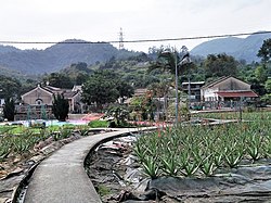
 Sik Lo in Yeung Ka Tsuen. | |
| Coordinates: 22°24′40″N 114°01′14″E / 22.411001°N 114.02063°E | |
| Country | People's Republic of China |
| Special administrative region | Hong Kong |
| District | Yuen Long District |
| Area | Tai Tong, Shap Pat Heung |
| Time zone | UTC+8:00 (HKT) |

Yeung Ka Tsuen (Chinese: 楊家村) is a village in Tai Tong, Shap Pat Heung, Yuen Long District, Hong Kong.
History
In the summer of 1942, when the Japanese army was reported to have come to raid the area, the guerrillas quickly evacuated with their firearms and hid themselves in the Tanchai Mountain behind Sulu. When the Japanese army failed to find the guerrillas, they took Yang Zhunan away and imprisoned him for more than a month. The Japanese tortured him to force him to give information about the guerrillas, but he refused, insisting that he did not know.[1]
Education
Yeung Ka Tsuen is in Primary One Admission (POA) School Net 73. Within the school net are multiple aided schools (operated independently but funded with government money) and one government school: South Yuen Long Government Primary School (南元朗官立小學).[2]
References
- ^ "香港元朗適廬:秘密大營救中轉站沉澱曆史足印". 香港新浪 (in Chinese (Hong Kong)). Retrieved 2022-10-20.
- ^ "POA School Net 73" (PDF). Education Bureau. Retrieved 2022-10-09.
External links
- Antiquities Advisory Board. Historic Building Appraisal. Sik Lo – Main Building, Yeung Ka Tsuen Pictures
- Antiquities Advisory Board. Historic Building Appraisal. Sik Lo, Ancillary Block, Yeung Ka Tsuen Pictures
- Antiquities Advisory Board. Historic Building Appraisal. Sik Lo, Entrance Gate, Yeung Ka Tsuen Pictures


