FAIR and interactive data graphics from a scientific knowledge graph
Contents
Shimamaki
島牧村 | |
|---|---|
Village | |
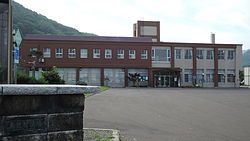
 Shimamaki Village hall | |
 Location of Shimamaki in Hokkaido (Shiribeshi Subprefecture) | |
| Coordinates: 42°42′N 140°4′E / 42.700°N 140.067°E | |
| Country | Japan |
| Region | Hokkaido |
| Prefecture | Hokkaido (Shiribeshi Subprefecture) |
| District | Shimamaki |
| Government | |
| • Mayor | Masaru Fujisawa |
| Area | |
• Total | 437.26 km2 (168.83 sq mi) |
| Population (September 30, 2016) | |
• Total | 1,560 |
| • Density | 3.6/km2 (9.2/sq mi) |
| Time zone | UTC+09:00 (JST) |
| City hall address | 83-1, Tomari, Shimamaki, Shimamaki-gun, Hokkaido 048-0621 |
| Website | www |
| Symbols | |
| Flower | Leontopodium japonicum |
| Tree | Fagus crenata |
Shimamaki (島牧村, Shimamaki-mura) is a village located in Shiribeshi Subprefecture, Hokkaido, Japan.
As of September 2016, the village has an estimated population of 1,560. The total area is 437.26 km2.
Geography
Shimamaki is located on the southern of the Shiribeshi Subprefecture. The name is derived from the Ainu word "Shuma-ko-mak", which means "Behind rocks".[1]
Neighboring towns
- Hiyama Subprefecture
- Oshima Subprefecture
- Shiribeshi Subprefecture
History
- 1906: The village of Higashishimamaki and the village of Nishishimamaki were founded.
- 1956: Two villages were merged to form the new village of Shimamaki.
Industries
The main industry of Shimamaki is fishery. Thirty percent of the villagers are engaged in it.[2]
Education
- Elementary school
- Shimamaki Elementary School
- Junior high school
- Shimamaki Junior High School
References
External links
 Media related to Shimamaki, Hokkaidō at Wikimedia Commons
- Official Website (in Japanese)


