Effects of the storage conditions on the stability of natural and synthetic cannabis in biological matrices for forensic toxicology analysis: An update from the literature
Kandungan
Penampilan
Dinkelland | |
|---|---|
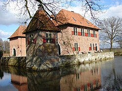
 Istana di Dinkelland | |
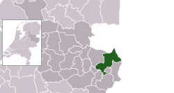
 Lokasi di Overijssel | |
| Koordinat: 52°22′N 7°0′E / 52.367°N 7.000°EKoordinat: 52°22′N 7°0′E / 52.367°N 7.000°E | |
| Negara | Netherlands |
| Wilayah | Overijssel |
| Pentadbiran | |
| • Badan | Majlis perbandaran |
| • Datuk Bandar | John Joosten (VVD) |
| Keluasan | |
| • Jumlah | 176.82 km2 (68.27 batu persegi) |
| • Tanah | 175.76 km2 (67.86 batu persegi) |
| • Air | 1.06 km2 (0.41 batu persegi) |
| Aras | 26 m (85 ft) |
| Penduduk (Ogos 2017)[4] | |
| • Jumlah | 26,280 |
| • Kepadatan | 150/km2 (400/batu persegi) |
| Zon waktu | UTC+1 (CET) |
| • Musim panas (DST) | UTC+2 (CEST) |
| Poskod | Sebahagian daripada julat 7500 dan 7600 |
| Nombor pendailan | 0541, 074 |
| Laman sesawang | www |
Dinkelland (sebutan (bantuan·info)) merupakan sebuah gemeente Belanda yang terletak di wilayah Overijssel. Pada tahun 2006 daerah ini memiliki penduduk sebanyak 26,064 orang.
Lihat pula
Rujukan
- ^ "Ineke Bakker (acting mayor)" (dalam bahasa Belanda). Gemeente Dinkelland. Dicapai pada 27 Mac 2014.
- ^ "Kerncijfers wijken en buurten" [Key figures for neighbourhoods]. CBS Statline (dalam bahasa Dutch). CBS. 2 July 2013. Dicapai pada 12 March 2014.CS1 maint: unrecognized language (link)
- ^ "Alatan poskod untuk 7591MA". Actueel Hoogtebestand Nederland (dalam bahasa Belanda). Het Waterschapshuis. Dicapai pada 27 Mac 2014.
- ^ "Bevolkingsontwikkeling; regio per maand" [Pertumbuhan populasi; kawasan per bulan]. CBS Statline (dalam bahasa Belanda). CBS. 27 Oktober 2017. Dicapai pada 27 Oktober 2017.


