Effects of the storage conditions on the stability of natural and synthetic cannabis in biological matrices for forensic toxicology analysis: An update from the literature
Contents
Konjščina | |
|---|---|
Village | |
 | |
| Country | |
| County | Krapina-Zagorje County |
| Government | |
| • Municipal Mayor | Mirko Krznar |
| Area | |
| • Village | 44.3 km2 (17.1 sq mi) |
| • Urban | 1.2 km2 (0.5 sq mi) |
| Population (2021)[2] | |
| • Village | 3,308 |
| • Density | 75/km2 (190/sq mi) |
| • Urban | 910 |
| • Urban density | 760/km2 (2,000/sq mi) |
| Time zone | UTC+1 (CET) |
| • Summer (DST) | UTC+2 (CEST) |
| Website | konjscina |

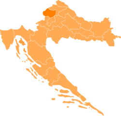
Konjščina (Croatian pronunciation: [kǒːɲʃtʃina]) is a village and municipality in Krapina-Zagorje County in Croatia. The city is about 30 km northeast of Zagreb. According to the 2011 census, there are 3,790 inhabitants in the area,[3] absolute majority which are Croats. It is connected by the D24 highway and R201 railway.
History
The city is known for the nearby fort [hr], located where the Selnica Stream flows into the Krapina River. The stone stronghold, named Citadel Selnica (Kaštel Selnica, old name for Konjščina). The stronghold was first mentioned in 1477, in documents given by King Matthias Corvinus by which he allowed Kristofor and Ivan Konjski to build a fort in Selnica. The stronghold was different from others in Croatia. While strongholds (forts) were typically built on high ground, for the advantage of height, the stronghold at Konjščina was Croatia's first wasserburg (water castle) a fort surrounded by much water. In 1544, Nikola IV Zrinski and Georg von Wildenstein, fled to find safety inside after being deceived and defeated by Ottoman raiders at a battle nearby.
References
- ^ Register of spatial units of the State Geodetic Administration of the Republic of Croatia. Wikidata Q119585703.
- ^ "Population by Age and Sex, by Settlements" (xlsx). Census of Population, Households and Dwellings in 2021. Zagreb: Croatian Bureau of Statistics. 2022.
- ^ "Population by Age and Sex, by Settlements, 2011 Census: Konjščina". Census of Population, Households and Dwellings 2011. Zagreb: Croatian Bureau of Statistics. December 2012.
External links
46°4′12″N 16°10′48″E / 46.07000°N 16.18000°E


