Effects of the storage conditions on the stability of natural and synthetic cannabis in biological matrices for forensic toxicology analysis: An update from the literature
Contents
Appearance
Sambalpur Airport | |||||||||||
|---|---|---|---|---|---|---|---|---|---|---|---|
| Summary | |||||||||||
| Airport type | Public | ||||||||||
| Owner | Government of Odisha | ||||||||||
| Serves | Sambalpur | ||||||||||
| Location | Sambalpur, Odisha, India | ||||||||||
| Elevation AMSL | 658 ft / 201 m | ||||||||||
| Coordinates | 21°34′49″N 84°00′20″E / 21.58028°N 84.00556°E | ||||||||||
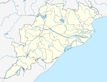
| Map | |||||||||||
 | |||||||||||
| Runways | |||||||||||
| |||||||||||
Hirakud Airstrip, also known as Sambalpur Airstrip, (ICAO: VEHK) is a public airstrip owned by Government of Odisha located 12 kilometres north of Sambalpur in western Odisha, India.[1][2][3]
References
- ^ World Aero Data[usurped]
- ^ "List of Airstrip in the State maintained by State Government" (PDF). ct.odisha.gov.in. Commerce and Transport Department, Government of Odisha. Archived from the original (PDF) on 14 January 2023. Retrieved 14 January 2023.
- ^ "AAI Unserved Airports" (PDF). aai.aero. Airports Authority of India.


