Type a search term to find related articles by LIMS subject matter experts gathered from the most trusted and dynamic collaboration tools in the laboratory informatics industry.
Lumberton, North Carolina | |
|---|---|
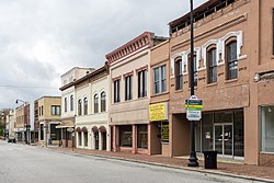
 North Elm Street | |
| Coordinates: 34°37′52″N 79°01′07″W / 34.63111°N 79.01861°W | |
| Country | United States |
| State | North Carolina |
| County | Robeson |
| Named for | Lumber River[1] |
| Government | |
| Area | |
| • Total | 17.84 sq mi (46.20 km2) |
| • Land | 17.76 sq mi (46.00 km2) |
| • Water | 0.08 sq mi (0.20 km2) |
| Elevation | 135 ft (41 m) |
| Population | |
| • Total | 19,025 |
| • Density | 1,071.29/sq mi (413.62/km2) |
| Time zone | UTC−5 (Eastern (EST)) |
| • Summer (DST) | UTC−4 (EDT) |
| ZIP codes | 28358-28360 |
| Area codes | 910, 472 |
| FIPS code | 37-39700[5] |
| GNIS feature ID | 2404974[3] |
| Website | www.ci.lumberton.nc.us |
Lumberton is a city in Robeson County, North Carolina, United States. It is the county seat of Robeson County, which is the largest county in the state by land area.[6]