Type a search term to find related articles by LIMS subject matter experts gathered from the most trusted and dynamic collaboration tools in the laboratory informatics industry.
| Trappes | |||
| — Oraș — | |||
 | |||
| |||
 Trappes (Franța) Poziția geografică în Franța | |||
| Coordonate: 48°46′36″N 2°00′06″E / 48.776666666667°N 2.0016666666667°E | |||
|---|---|---|---|
| Țară | |||
| Regiune | Île-de-France | ||
| Departament | Yvelines | ||
| Guvernare | |||
| - Primar | Guy Malandain[*][1] (Partidul Socialist, ) | ||
| Suprafață[2] | |||
| - Total | 13,47 km² | ||
| Altitudine[4] | 174 m.d.m. | ||
| Populație (1999) | |||
| - Total | 28.812 locuitori | ||
| - Densitate | 2,139 loc./km² | ||
| Fus orar | UTC+1 | ||
| Cod poștal | 78190[3] | ||
| Localități înfrățite | |||
| - Castiglione del Lago | Italia | ||
| - Congleton | Regatul Unit | ||
| - Kopřivnice | Cehia | ||
| - Podor[*] | Senegal | ||
| Prezență online | |||
| Sit Oficial GeoNames OpenStreetMap relation | |||
 | |||
| Modifică date / | |||
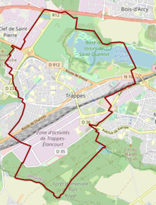
Trappes este un oraș în Franța, în departamentul Yvelines, în regiunea Île-de-France.