Type a search term to find related articles by LIMS subject matter experts gathered from the most trusted and dynamic collaboration tools in the laboratory informatics industry.
| District in Zwitserland | |||
|---|---|---|---|

| |||
| Situering | |||
| Kanton | Fribourg | ||
| BFS/OFS/UST-code | 1003 | ||
| Coördinaten | 46°36'27"NB, 7°6'26"OL | ||
| Algemeen | |||
| Oppervlakte | 489,4 km² | ||
| Inwoners (31-12-2017) |
54.431 (80,7 inw./km²) | ||
| Overig | |||
| Website | Préfecture de la Gruyère | ||
| Detailkaart | |||

| |||
| Gemeenten van het district Gruyère | |||
| |||
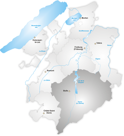
Gruyère (Frans: District de la Gruyère, Duits: Greyerz) is een van de zeven districten van het Zwitserse kanton Fribourg. Tot het gebied behoren 29 gemeenten:
| Gemeentenaam | Inwoners (1,1.2003) |
Oppervlakte (km²) |
|---|---|---|
| Bas-Intyamon | 1011 | 33,27 |
| Botterens | 472 | 1,99 |
| Broc | 2126 | 10,06 |
| Bulle | 16.041 | 12,42 |
| Cerniat | 338 | 33,78 |
| Charmey | 1651 | 78,44 |
| Châtel-sur-Montsalvens | 215 | 2,00 |
| Corbières | 369 | 4,17 |
| Crésuz | 273 | 1,80 |
| Echarlens | 567 | 4,61 |
| Grandvillard | 622 | 24,22 |
| Gruyères | 1556 | 28,39 |
| Hauteville | 500 | 10,56 |
| Haut-Intyamon | 1405 | 60,44 |
| Jaun | 680 | 55,24 |
| La Roche | 1330 | 24,03 |
| Le Pâquier | 958 | 4,50 |
| Marsens | 1395 | 7,79 |
| Morlon | 561 | 2,50 |
| Pont-en-Ogoz | 1455 | 9,95 |
| Pont-la-Ville | 504 | 4,33 |
| Riaz | 1798 | 7,78 |
| Sâles | 1273 | 18,78 |
| Sorens | 816 | 8,74 |
| Vaulruz | 894 | 10,09 |
| Villarvolard | 240 | 5,46 |
| Vuadens | 1733 | 10,49 |